
Garmin eTrex SE
4.2Editor score
Up to 168-hour battery life
Compact 2.2-inch display
Multi-GNSS satellite support
Water-resistant construction
The Pacific Crest Trail stretches across California, Oregon, and Washington, where reliable navigation can mean everything from finding a water source to identifying a safe descent in changing weather. A purpose-built handheld GPS gives backpackers the positioning accuracy, topographic detail, and battery endurance required for long-distance trail travel.
This guide compares ten GPS handhelds suited to PCT hiking, paying particular attention to display readability, satellite reception, route creation, topographic mapping, physical controls, battery life, and the availability of emergency communications. The list includes conventional mapping units, lightweight models, and satellite communicators with broader safety features.
Each review explains who should consider the device, where it fits into a PCT kit, and which compromises may matter. Ratings and product details reflect the supplied listings, while features can vary by location and subscription status. Prices and promotions change frequently, so check the current listing before making a final purchase.
4.2Editor score

4.6Editor score

5.0Editor score
As an Amazon Associate we earn from qualifying purchases.
The comparison below highlights display size, positioning systems, navigation hardware, and endurance. It is designed to show how compact trail devices differ from high-resolution mapping units and satellite-equipped emergency communicators.
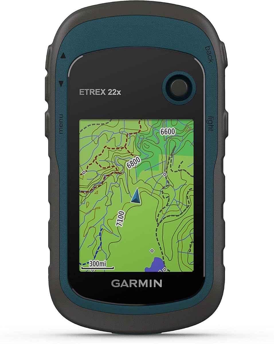




The Garmin eTrex 22x combines a simple handheld design with the topographic mapping and route-following tools needed for a self-supported PCT trip. Its 4.3 rating reflects a well-regarded balance of durability, affordability, and navigation capability. The 2.2-inch color screen is small by modern standards, but its sunlight readability and physical button layout remain useful when wet, cold, or moving quickly.
We may earn a commission when you buy through this link, at no additional cost to you.
TopoActive maps arrive preloaded with routable roads and trails, making the unit more useful out of the box than a basic coordinate-only receiver. GPS and GLONASS support improve positioning in challenging terrain, while 8 GB of internal memory and a microSD slot provide room for downloaded maps. The listed battery life reaches 25 hours in GPS mode with two AA batteries, enough for many long PCT segments when the device is used responsibly.
The main limitation is the absence of an electronic compass and barometric altimeter. Those sensors would help when a hiker stops, moves slowly, or needs a reliable heading in changing terrain. There is also no satellite communicator in this model, so emergency messaging still depends on a separate device or the coverage of a communications partner.
This is a strong choice for hikers who want dependable navigation without paying for advanced sensors or satellite subscription features. It is particularly appropriate for route-based travel, section hiking, and maintaining a simple map-and-track workflow. For PCT users who prioritize simplicity, solid maps, and manageable size, the eTrex 22x remains a compelling all-around navigator.
Preloaded TopoActive maps turn the eTrex 22x into a practical trail tool immediately. Its storage can also hold additional map regions, making it easier to keep coverage for multiple PCT states in one device.
The physical interface is straightforward to operate while walking or wearing gloves. The small display favors battery efficiency and pack weight, although route review is less comfortable than on a larger touchscreen.
We may earn a commission when you buy through this link, at no additional cost to you.
This compact handheld GPS offers a 3.2-inch sunlight-readable color display, physical buttons, and 32 GB of internal storage. Its 3.9 rating places it behind the more established Garmin models, yet the listed specifications make it a relevant choice for hikers who want a modern screen and generous map storage. The device supports GPS, Galileo, BeiDou, and QZSS positioning.
We may earn a commission when you buy through this link, at no additional cost to you.
A 3-axis compass and barometric altimeter add useful trail features, including a heading while stationary and elevation information. The included topographic map coverage and internal memory are designed for downloads, while route and waypoint functions can help users record trips and navigate back to a starting point. Its rechargeable battery is listed at up to 36 hours in full charge.
The product is water-resistant to an IP66 rating, which is appropriate for ordinary rain and splashes, but it is not equivalent to immersion protection. Its 3.9 rating suggests that some buyers may have found aspects of usability or performance less compelling. The less established brand identity may also make long-term support and accessory compatibility less certain than with a widely established manufacturer.
PCT hikers who prioritize screen area, storage, and physical controls may find this device appealing. It is not the most highly rated option in the comparison, but the feature set is substantial for a standalone navigation unit. Confirm map detail, accessory standards, and current user feedback before committing to it for a long remote trail.
The 3.2-inch display offers more room for examining junctions than the 2.2-inch screens common in compact eTrex models. Physical buttons still preserve a tactile interface when gloves or wet conditions make a touchscreen less dependable.
Compass and altimeter functions support stationary navigation and elevation awareness. Thirty-two gigabytes of internal memory gives the device substantial room for map downloads and stored PCT routes.
We may earn a commission when you buy through this link, at no additional cost to you.
The Garmin GPSMAP 65s is the most balanced conventional mapping device in this comparison. Its 4.6 rating reflects strong reception of buyers who value accuracy, a readable color display, and a dependable button-operated interface. Multi-band GNSS technology is the central feature, helping maintain precise positioning in forests, steep country, and urban canyon-like terrain.
We may earn a commission when you buy through this link, at no additional cost to you.
The 2.6-inch sunlight-readable screen offers more viewing area than a basic eTrex while retaining physical controls for trail use. A 3-axis compass and barometric altimeter help hikers establish direction and elevation. Routable TopoActive maps and a federal public land map for the United States cover many PCT navigation needs, while compatibility with Garmin Explore assists with route and track management.
This unit does not include inReach satellite communication, so it is not a complete standalone solution for emergencies far from cellular coverage. It also sits at a higher tier than the simplest Garmin handhelds, making cost a consideration for hikers who only need coordinate tracking. The physical controls resist accidental input, but a 2.6-inch screen remains less spacious than the 3.5-inch hybrid display on the premium model.
The GPSMAP 65s is best for PCT hikers who want dependable navigation without committing to a satellite subscription. It is particularly attractive to hikers crossing dense vegetation, complicated terrain, or areas where extra positional accuracy can simplify route confirmation. For most route-based PCT travel, it is the most versatile choice in the roundup.
Multi-band technology is especially relevant where a conventional GPS-only receiver may lose accuracy. Combined with expanded global navigation satellite support, it gives hikers a stronger basis for confirming their position near cover, cliffs, and steep slopes.
Garmin avoids making the GPSMAP 65s dependent on touch input. Its color display is large enough for route review, while the buttons remain useful with cold fingers, gloves, rain, or movement.
We may earn a commission when you buy through this link, at no additional cost to you.
The Garmin eTrex SE stands apart through its extraordinary battery claims, including up to 168 hours in standard mode and up to 1,800 hours in expedition mode. Its 4.2 rating indicates a generally well-received unit with a practical 2.2-inch sunlight-readable display, water resistance, and broad multi-GNSS support.
We may earn a commission when you buy through this link, at no additional cost to you.
Compatibility with the Garmin Explore app allows compatible smartphone users to plan trips, receive software updates, view Active Weather, and manage notifications. Automatic Geocaching Live updates add another layer of utility, although the PCT focus makes navigation and route management more significant. A digital compass provides a stationary heading, and the device supports GPS, GLONASS, Galileo, BeiDou, and QZSS.
Field-replaceable AA batteries add practical resilience because a hiker can carry conventional batteries rather than depend on a proprietary pack or charging cable. The stated battery figures vary dramatically by operating mode, so actual results will depend on settings, temperature, and satellite activity. The small display and absence of satellite communications are the two most important limitations.
This is an excellent choice for PCT hikers who want a navigation device that can remain powered for many days or weeks without charging. It is also suitable for people who prefer simple physical controls and field-replaceable power. Those wanting two-way emergency messaging should look toward an inReach model or carry a separate communicator.
A 168-hour standard-mode claim offers remarkable freedom from charging. It is particularly useful on long trail segments, during weather delays, and for hikers who carry power banks for other devices but do not want to depend on them for navigation.
The eTrex SE keeps the straightforward design associated with Garmin handhelds. Its sunlight-readable screen and physical controls prioritize dependable use over visual media, animated graphics, or a large touch interface.
We may earn a commission when you buy through this link, at no additional cost to you.
The S190 combines a large 3.2-inch color screen, 64 GB of internal storage, and a worldwide basemap in a compact handheld format. Its perfect 5.0 rating is a strong listing signal, although a high aggregate score does not replace reviewing the map-loading instructions and understanding the device's waterproofing limits.
We may earn a commission when you buy through this link, at no additional cost to you.
GPS, BeiDou, Galileo, and QZSS support broaden satellite options for route tracking. The device records a route and can guide a hiker back along it, while its 3-axis compass displays heading even when stationary. Preloaded USA topographic maps cover the PCT states, and the large storage capacity creates room for more detailed regional files.
The most important caveat appears in the supplied product information: the included map may become blank when zoomed in further because only a limited state map tier is downloaded. Users are directed to obtain fuller map files through the device website and follow the provided video or manual instructions. IP64 protection is suitable for splashes and outdoor exposure but is less comprehensive than IPX7 waterproofing.
The S190 is worth considering for PCT hikers who want generous storage and a roomy screen. It may be especially useful for users who intend to download extensive maps and prefer keeping the full navigation workflow on one device. The map setup requires more attention than a standard preloaded unit, so buyers should confirm compatibility with their computers and understand the additional download process before the hike.
Sixty-four gigabytes provides more internal capacity than most conventional handhelds in the group. That makes the S190 attractive to hikers who want detailed regional maps, saved routes, and waypoint collections available throughout a long trip.
The limited default map tier can frustrate users who expect close inspection of every trail. Downloading more detailed files before leaving is essential if the device will serve as the primary PCT map.
We may earn a commission when you buy through this link, at no additional cost to you.
The Garmin eTrex 32x is a rugged, sensor-equipped version of the eTrex 32x line with a 4.2 rating. Its 2.2-inch color display, physical controls, and 25-hour battery target hikers who want a no-nonsense trail navigator. It includes 8 GB of internal memory and a microSD slot for expanded map storage.
We may earn a commission when you buy through this link, at no additional cost to you.
Preloaded TopoActive maps contain routable roads and trails for hiking and cycling. Unlike the eTrex 22x, the 32x adds a 3-axis compass and barometric altimeter, allowing a stationary heading and more useful elevation information. GPS and GLONASS support are valuable in covered or difficult terrain, though the unit does not offer the multi-band positioning found in newer Garmin models.
The main tradeoff is technological age relative to the GPSMAP 65s and H1i Plus. Its satellite support is less expansive, its display is smaller, and it lacks satellite communications. A 25-hour runtime is adequate for many resupply intervals but less comforting on remote stretches where charging opportunities are unpredictable.
PCT hikers who want rugged physical controls, expandable storage, and dedicated sensors in a conventional handheld will find the 32x appealing. It is a particularly logical choice for users who value the eTrex form factor and do not need touchscreen controls or emergency messaging. Check current availability and compare the older electronics with newer alternatives before purchasing.
The electronic compass and barometric altimeter make this model more versatile than a basic coordinate and route tracker. These readings are useful at breaks, junctions, and steep sections where a moving GPS position alone may not answer every question.
Eight gigabytes of internal memory and a microSD card slot provide a practical combination for downloading maps. The removable-card option also gives travelers flexibility when they want to carry specific regions without relying solely on built-in storage.
We may earn a commission when you buy through this link, at no additional cost to you.
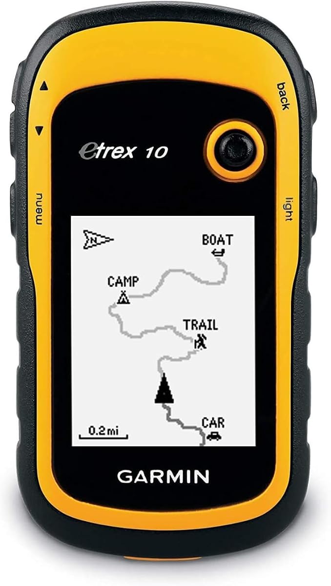
The Garmin eTrex 10 is a straightforward worldwide GPS navigator with a 4.3 rating and a monochrome 2.2-inch display. It is designed for basic wayfinding rather than detailed cartography or advanced trail data, making it most appropriate for hikers who already understand their route and want a dependable position reference.
We may earn a commission when you buy through this link, at no additional cost to you.
A preloaded worldwide basemap provides broad geographic context. HotFix and GLONASS support help the receiver acquire and maintain a reliable signal, while IPX7 waterproofing protects against rain, splashes, and immersion conditions permitted by the standard. The eTrex 10 also supports paperless geocaching and compatible Garmin spine mounting accessories.
Two AA batteries provide up to 20 hours of use, which is shorter than many contemporary options but sufficient for many standard PCT segments. The display is not color, and the device lacks a digital compass and barometric altimeter. It therefore falls short of the feature set required by hikers who want detailed topo maps, elevation trends, or satellite emergency communication.
This model can be a sound secondary GPS or a simple primary unit for practiced navigators. It works particularly well for through-hikers who maintain a strong paper-map habit and want a compact device to confirm position. Most PCT navigation systems, however, will benefit from the richer mapping and sensor options of the eTrex 22x, 32x, or SE.
The eTrex 10 reduces navigation to coordinates, a basic basemap, and stored waypoints. That simplicity can be reassuring for users who do not want complex menus, touchscreens, or active route guidance.
Its IPX7 rating provides stronger water protection than splash-resistant alternatives. That matters in an exposed mountain environment where rain, stream spray, and wet gear are normal trail conditions.
We may earn a commission when you buy through this link, at no additional cost to you.
The Garmin GPSMAP 67i combines a 3-inch color mapping display with Iridium satellite communications, giving it a strong safety role beyond ordinary trail navigation. Its 4.6 rating is among the strongest in the comparison. The renewed listing adds a condition-related caveat, but the listed features make this a capable choice for remote PCT sections where cellular coverage is unreliable.
We may earn a commission when you buy through this link, at no additional cost to you.
The unit supports two-way messaging and location tracking through the global Iridium network. An interactive SOS can connect with a staffed emergency response coordination center when an active subscription is in place. The screen is sunlight readable, and the mapping package includes TopoActive, satellite imagery access, multi-band GNSS, and navigation sensors. Smartphone pairing adds weather and geocaching features.
The major requirement is an active satellite subscription for communication services. Users must also follow regulations in jurisdictions where satellite devices are restricted. A rechargeable lithium battery provides up to 165 hours in 10-minute tracking mode and up to 425 hours in expedition mode, but actual messaging use affects consumption. Optional premium mapping content may require a separate subscription.
This is a compelling choice for PCT hikers who regard emergency communication as a core safety tool rather than an optional accessory. It is also well suited to long, remote stretches of the trail and to users who want mapping, weather, tracking, and SOS functions in one device. Verify the renewed condition, subscription terms, and regulatory requirements before departure.
Iridium-based messaging allows a hiker to communicate and share location beyond ordinary cellular networks. This can support check-ins, route updates, and emergency response when the trail enters remote or heavily wooded terrain.
Combining a color screen, topographic mapping, multi-band positioning, sensors, and satellite SOS reduces the number of devices a hiker must carry. It is especially useful for solo travelers and hikers crossing long stretches with limited access to roads or assistance.
We may earn a commission when you buy through this link, at no additional cost to you.
The Garmin GPSMAP H1i Plus is the most feature-complete PCT navigation device in the roundup, earning a perfect 5.0 rating. It combines a 3.5-inch sunlight-readable touchscreen with rugged physical buttons, multi-band GPS, preloaded North American maps, and inReach Plus satellite communication. It is designed for hikers who want navigation, connectivity, and safety tools in one expedition-oriented unit.
We may earn a commission when you buy through this link, at no additional cost to you.
With an active subscription, inReach Plus can send and receive text messages, exchange photos, share voice messages, activate interactive SOS, and provide live location sharing. Built-in barometric, compass, and altitude sensors support field awareness, while ascent planning helps hikers anticipate climbs. Downloadable satellite imagery and optional Outdoor Maps+ content add more context beyond standard topographic mapping.
The H1i Plus is tested to MIL-STD 810 standards for water, shock, vibration, and temperature resistance. A built-in LED flashlight and loud siren provide additional emergency utility. It also includes useful carrying accessories in the bundle, such as charging cables, a power bank, a car adapter, a cleaning kit, and a USB adapter. The primary compromises are the device's high cost and the recurring subscription required for satellite communication services.
This premium model is best for experienced long-distance hikers, solo travelers, and PCT resupply staff who want dependable mapping plus flexible off-grid communication. It also suits users who appreciate both a modern touchscreen and tactile buttons. For hikers who only need local navigation, the feature set may be excessive, but for expedition-grade use it offers the strongest all-around capability in this list.
The ability to exchange photos and voice messages gives the inReach Plus system more flexibility than basic two-way satellite text. Those functions can help companions understand conditions or emergencies when detailed written descriptions are inconvenient.
A glove-friendly, scratch-resistant touchscreen works well when the hiker is stationary, while customizable physical buttons support operation in cold, wet, or unstable conditions. This hybrid approach is particularly appropriate along technical PCT terrain.
The listed 145-hour GPS mode and 840-hour expedition mode provide enormous operating flexibility. Carry-in reserves are easier to maintain when the navigation device can remain powered through a delayed resupply or extended weather interruption.
We may earn a commission when you buy through this link, at no additional cost to you.
The Garmin GPSMAP 66i is a renewed, 3-inch handheld that combines TopoActive navigation with inReach satellite communication. Its 4.5 rating places it among the better-rated products in the guide. The device supports two-way messaging through the Iridium network, interactive SOS, location tracking, and direct-to-device Birdseye satellite imagery downloads.
We may earn a commission when you buy through this link, at no additional cost to you.
Multiple global navigation satellite systems and navigation sensors support field use, while smartphone connectivity can provide active weather forecasts and Geocaching Live. Compatibility with Garmin Explore helps manage waypoints, routes, activities, collections, tracks, and trip data. This makes the 66i a versatile option for hikers who want one device to handle both planning and field navigation.
The rechargeable battery is listed for up to 35 hours in 10-minute tracking mode, one-minute tracking with the display off, and 200 hours in expedition mode using 30-minute tracking. A satellite subscription is required for messaging and SOS, and legal restrictions may apply in some jurisdictions. Because this is a renewed listing, buyers should examine the condition, included accessories, warranty information, and battery performance carefully.
The 66i is a strong choice for PCT hikers who want satellite safety and navigation without moving up to the larger H1i Plus platform. It is a sensible middle ground between a conventional mapping handheld and a premium communications device. It particularly suits users who value bird's-eye imagery, weather access, and reliable expedition-mode battery life.
Birdseye downloads can reveal terrain relationships that are easier to understand from above. Although the aerial view does not replace topographic detail, it can help hikers orient themselves around valleys, ridgelines, and branching drainages.
Two-way messaging, location sharing, and interactive SOS functions turn the 66i into more than a map unit. They add valuable layers of coordination and emergency response for long remote trail segments.
We may earn a commission when you buy through this link, at no additional cost to you.
A PCT GPS should combine dependable positioning, useful maps, readable controls, and enough power for the distance between resupply opportunities. The right balance depends on route-finding habits, party size, satellite coverage, and the importance placed on emergency communication.
Positioning accuracy becomes most important near junctions, under dense forest cover, in steep terrain, or anywhere a wrong turn adds meaningful mileage. Devices with multiple global navigation satellite systems can maintain a fix by using more than GPS signals. Multi-band models add another layer by receiving additional frequency bands, which can improve precision in challenging environments. The GPSMAP 65s and H1i Plus are the strongest choices in this guide when accuracy under difficult conditions is the priority.
Choose the most capable positioning system your route and budget justify. A multi-GNSS receiver is already a major improvement over a basic GPS-only unit.
The PCT crosses California, Oregon, and Washington, so a useful device should include detailed topographic information and ideally routable trails. The Garmin models in this list use TopoActive mapping, while the generic handheld devices list preloaded USA topographic maps. Map zoom level matters because a broad basemap can fail to reveal small paths, drainage crossings, or roads clearly enough for real navigation.
Confirm that the maps are preloaded or downloadable for every PCT state you will visit. For detailed map use, make the necessary downloads before leaving reliable internet or computer access.
PCT screens may be viewed in intense sun, deep shade, rain, or while moving across uneven ground. Sunlight-readable color displays are easier to interpret than monochrome screens, but physical buttons often work better than a touchscreen with wet or gloved hands. The H1i Plus offers a hybrid interface, while the eTrex products use a smaller screen and tactile controls.
Balance screen size against pack bulk. A larger display improves route review, but a compact unit can be easier to operate one-handed and may encourage a simpler, less distracting navigation workflow.
Battery expectations should reflect the longest possible interval between reliable charging opportunities. Standard GPS mode is not the only relevant setting because frequent tracking, brighter screens, and satellite communications consume more energy. The eTrex SE offers exceptional standard and expedition endurance, while the inReach models provide strong performance when tracking intervals are reduced. Rechargeable units are convenient, but field-replaceable AA batteries offer more flexibility for some hikers.
Match the power system to your resupply rhythm and expected weather. Carry spare batteries or a charged power bank for long off-grid sections, regardless of the listed maximum.
A 3-axis compass provides a heading while stopped, while a barometric altimeter adds elevation information and can support ascent-related functions. These sensors are useful when a hiker pauses at a junction, wants to identify a ridge direction, or needs to check elevation against a trail map. The eTrex 32x, generic 3.2-inch handheld, GPSMAP 65s, and H1i Plus include this combination.
Sensors do not replace a map, but they make a handheld more versatile during breaks and slow-moving navigation. Check that both functions are included rather than assuming every rugged unit has them.
Most of the PCT has some cellular coverage, but gaps occur in remote valleys, forested canyons, and high terrain. inReach models add two-way satellite messaging, location sharing, and interactive SOS through a staffed response center. They are especially relevant to solo hikers and travelers on stretches away from roads. The trade-offs are subscription requirements, regulatory restrictions in some locations, and lower battery endurance during communication use.
Treat satellite capability as a safety system rather than merely another navigation feature. Read the activation steps, understand the subscription, test the device, and know the legal rules before the trail.
PCT hiker may need maps for several states, saved routes, waypoints, and track data. Internal memory of 8 GB may suffice for a single regional trip, while 32 GB or 64 GB offers more room for detailed downloads. A microSD slot provides additional flexibility and makes it easier to carry selected regional map sets. A worldwide basemap adds general orientation in areas outside the normal PCT corridor.
Choose storage according to how much of the trail you expect to navigate with the device. If it is a backup for a phone or paper map, modest storage may be sufficient; a primary navigator benefits from more.
A handheld must tolerate rain, abrasion, dust, accidental drops, and changing temperatures. IPX7 devices offer strong water protection, IP66 and IP64 units are designed primarily for rain and splashes, and the H1i Plus is tested to MIL-STD 810 standards. Screen size, battery design, and included accessories also affect pack weight. A slightly heavier device with a large screen and emergency communication may still be rational for a long expedition.
Prioritize protection and reliability over the smallest possible unit. A navigation tool that remains readable and powered in bad conditions is more valuable than a lighter model that compromises either durability or endurance.
Before the trail, update the device software, verify that all required PCT maps are present, and test route creation and waypoint functions. Download or load the relevant map regions while reliable internet and computer access are available. If the model supports Bluetooth or mobile apps, pair it with a compatible phone and learn where the phone-dependent features end. Place the device in airplane mode for the hike when cellular connectivity is not needed, then enable Bluetooth selectively.
At the trailhead, give the unit enough time to acquire a stable satellite fix before beginning. Record your start point, review the first major junctions, and confirm that the display is readable at the likely viewing angle. Save essential camp, water, road-access, and bail-out points. Use the compass and altimeter as supporting references, but continue to follow the map and track rather than depending on a single numeric reading. A backup paper map remains sensible even when the handheld is the primary tool.
During the hike, keep the unit accessible but protected, and use a case that does not block sound or controls. Check the battery estimate at every resupply and carry the appropriate reserve power. Clean mud from buttons and the charging port after wet weather, and dry the device before storage. Do not expose a unit to charging moisture or use a damaged cable. Periodically verify the recorded track against the official PCT route, and download the device's map updates whenever you regain dependable connectivity.
A dedicated GPS is generally better for long-distance navigation because it offers longer battery life, physical controls, stronger map handling, and less dependence on cellular service. A phone remains useful for maps, weather, messaging, and documents when coverage and power are available. The most resilient approach is to carry both or to carry a phone and a lightweight dedicated navigator with a paper-map backup.
Satellite messaging is not required for every PCT trip, but it is valuable for solo hikers and remote sections with inconsistent cellular coverage. An inReach device can provide two-way messages, location sharing, and emergency SOS functions away from cell networks. Hikers should understand subscription costs, testing procedures, device regulations, and battery impacts before relying on it.
The Garmin eTrex 22x is among the simplest complete mapping choices because it includes routable TopoActive maps, physical controls, and straightforward navigation. The eTrex 10 is even more basic but has a monochrome display and fewer advanced features. Simplicity should be balanced against map detail, so a hiker should not equate fewer features with better navigation.
Battery needs vary with resupply spacing, tracking frequency, temperature, screen use, and satellite messaging. A 25-hour device may cover a common section comfortably, while 35 to 36 hours offers more margin during delays. Expedition mode can extend endurance substantially, but the unit may be less useful for active tracking. Always carry a backup power plan for remote stretches.
Yes, complete all essential map downloads before leaving reliable internet and computer access. Some devices include a limited default map tier, and detailed files may be larger or more precise than what comes preloaded. Also download any critical manuals, verify that the files display correctly, and carry a paper map in case the handheld fails.
No. IPX7 indicates strong waterproof protection, while IP66 and IP64 generally emphasize resistance to water jets, rain, and splashes. Terms are not interchangeable, and every manufacturer rating applies to specified conditions. Keep ports covered where practical, dry the unit after severe weather, and consult the manual before exposing it to water beyond its rating.
Yes. Their core satellite positioning and stored topographic mapping do not require cellular service, and conventional GPS handhelds do not need a satellite communication subscription. Cell service adds convenience through weather, app pairing, and some live features, while inReach service adds off-grid messaging and SOS capabilities.
A paper map remains a sensible backup because batteries can fail, controls can be misused, and software updates can introduce problems. It also helps hikers understand the larger route and recognize terrain beyond a small screen. Keep it accessible, mark bailout points, and practice using it alongside the electronic unit rather than treating it as a nearly forgotten emergency item.
The Garmin GPSMAP 65s is the most balanced conventional choice for most PCT hikers, combining multi-band positioning, a readable color display, physical controls, topographic maps, and useful sensors. The Garmin eTrex SE stands out for extraordinary battery endurance and field-replaceable AA batteries, making it a strong choice for navigation-focused hikers who want to go a long time between charges.
Priority should reflect the route and the traveler. Choose a basic unit only if detailed maps, sensors, and route creation are not important. Pick a compact eTrex for weight and endurance, a GPSMAP for advanced positioning, or an inReach model when off-grid messaging and emergency SOS justify a subscription. Keep a paper map and phone backup even when the handheld is the primary navigator.
Ratings, map availability, subscription terms, and promotions can change, so verify the current product listing before purchasing. Check the included map detail, regional downloads, battery configuration, and satellite-service terms. Taking time to prepare the device before the hike will have a greater effect on navigation reliability than small differences between otherwise suitable models.
