
Digital Compass Altimeter Handheld Hiking Thermometer 8 in 1
3.4Editor score
Eight-in-one outdoor functions
Wide 29,500-foot altitude range
Backlit digital display
A handheld altimeter can add useful context to a hike, climbing trip, hunt, fishing outing, or mountain drive by showing elevation and tracking changes as you move. The best model depends on whether you prioritize simple mechanical operation, digital precision, navigation, weather sensing, or compact portability.
We compared all 10 products by examining their stated altitude ranges, measurement methods, barometer and compass functions, temperature capabilities, construction, display features, and intended outdoor uses. The list includes analog pressure gauges, digital multifunction instruments, sighting clinometers, and a full-featured handheld GPS device.
Each review explains what the product is best suited for, along with the strengths and limitations visible in its specifications. The top selections represent budget, overall, and premium options, while retail pricing and availability can change over time, so readers should confirm current details before purchasing.
3.4Editor score
4.3Editor score

4.6Editor score
As an Amazon Associate we earn from qualifying purchases.
This side-by-side comparison covers ten distinct approaches to handheld altitude measurement, ranging from pocket-sized sighting clinometers to navigation-focused GPS units. Compare the measurement method, altitude range, supporting functions, and construction to find the option that best matches your outdoor activities.


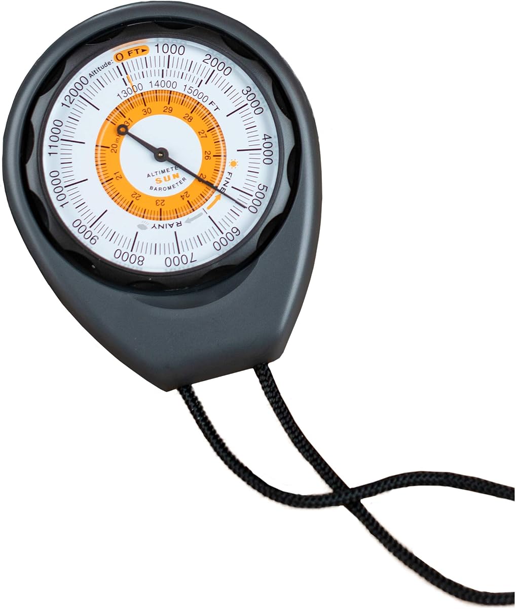
The Sun Company Altimeter 203 is a straightforward analog altimeter and barometer built for hikers, backpackers, campers, anglers, and drivers who want elevation information without managing electronics. Its 4.3 rating reflects a generally favorable user response, while its defining advantage is the uncomplicated, battery-free design. The instrument estimates elevation from surrounding barometric pressure and presents the result on a clear mechanical scale.
We may earn a commission when you buy through this link, at no additional cost to you.
Its adjustable dial is the most important operational feature. Users can account for high- or low-pressure systems when establishing a reference, helping the gauge provide a more appropriate reading than an uncalibrated pressure-based instrument. The face also measures barometric pressure in inches of mercury and includes a weather-trend indicator, so it offers useful context beyond a single elevation number. A rugged ABS housing protects the mechanism, and the included lanyard makes it convenient to carry on a trail or keep within reach in a vehicle.
The main compromises are inherent to an analog design. Altitude is not presented as a precise digital number, so interpreting small changes takes more experience than reading a screen. The stated range also tops out at 15,000 feet, which may be limiting for serious high-alpine trips. Most importantly, the reading depends on correct calibration, and weather-related pressure shifts can affect the result when the reference is not updated. Nevertheless, these drawbacks are modest compared with the benefit of having a dependable instrument that never asks for a battery.
This is the strongest general-purpose choice in the roundup because it combines a broad altitude scale, manual calibration, portability, and no ongoing power requirement. It is particularly well suited to someone who values simplicity over advanced data logging. For technical navigation, digital charting, or route tracking, a multifunction electronic model would be more appropriate, but for quick elevation checks and weather awareness, the Altimeter 203 offers an especially balanced package.
The analog pressure mechanism is useful where charging or spare batteries would be inconvenient. Once calibrated, it can remain in a pack and provide a quick elevation reference without menus, sensor recalibration prompts, or charging interruptions.
The adjustment dial allows users to compensate for high- and low-pressure systems. Reviewers and users should make that adjustment when conditions change substantially, particularly if the instrument is being used to monitor meaningful elevation gain.
We may earn a commission when you buy through this link, at no additional cost to you.
The BTMETER BT-100WM is primarily a handheld anemometer, but its broad collection of sensors makes it a strong choice for users who want altitude within a broader set of environmental readings. The device has a 4.1 rating and measures wind speed, wind temperature, wind chill, relative humidity, dew point, barometric pressure, and altitude. That combination is valuable for long-range shooting, hunting, sailing, kite flying, drone operation, weather observation, and airflow testing.
We may earn a commission when you buy through this link, at no additional cost to you.
The altitude measurement range extends from zero to 19,685 feet, giving it more vertical scope than the classic Sun Company analog gauges. Its LCD is backlit for day or nighttime use, while the display can present current, maximum, minimum, and average wind readings in miles per hour, feet per minute, kilometers per hour, meters per second, or knots. Pressure and elevation units can also be changed, which makes the instrument adaptable to different tasks and regional preferences.
Data recording is a notable feature for users who want to compare conditions over time. The meter can log 16 groups of barometric pressure information, enabling users to record, review, and examine relationships among pressure, temperature, humidity, and elevation. The stated wind-speed range is 0.67 to 67.1 miles per hour, with a specified accuracy tolerance of plus or minus 5 percent. As a battery-powered device with an automatic shutdown and low-battery reminder, it requires slightly more upkeep than an analog altimeter.
The BT-100WM is best for someone who needs altitude and weather data together rather than elevation alone. A dedicated pressure-based altimeter may be simpler for routine trail use, while this meter shines when wind and humidity influence a trip, hunt, flight, or shooting decision. It is a practical all-in-one field instrument for users willing to navigate a larger menu of measurements.
Wind speed, temperature, humidity, dew point, and pressure are all available from the same handheld unit. This makes it easier to evaluate changing conditions without carrying several separate instruments.
The 16-group recording function adds value for comparative observations. Users can preserve readings over time and review how altitude relates to barometric pressure and surrounding weather conditions.
We may earn a commission when you buy through this link, at no additional cost to you.
The Digital Compass Altimeter Handheld Hiking Thermometer 8 in 1 is a feature-dense budget device aimed at hikers, campers, mountaineers, and outdoor sports participants. It combines an altimeter, barometer, electronic compass, thermometer, clock, and weather information in one handheld unit. Its 3.4 rating is the lowest among the three budget-oriented multi-function choices in this list, so buyers should consider the trade-offs between extensive functionality and the strength of its customer feedback.
We may earn a commission when you buy through this link, at no additional cost to you.
The stated altitude range extends from minus 2,300 feet to 29,500 feet, with a resolution of approximately 3.3 feet. That range makes it suitable for monitoring elevation changes across a very broad range of environments. Its barometer measures from 300 to 1,100 millibars at 0.1-millibar resolution, while the temperature function covers 14 to 140 degrees Fahrenheit and can switch between Fahrenheit and Celsius. An eight-direction electronic compass adjusts according to the external magnetic field.
The five-second electronic backlight improves readability in low-light situations, and the included carrying rope helps prevent the instrument from being misplaced during an activity. On the other hand, the limited directional display is less comprehensive than a full compass with finer bearings, and the modest rating suggests that some buyers may not have found the overall experience fully satisfying. Buyers should also account for the possibility that a multifunction device does not perform every individual function to the same level as a specialized device.
This instrument is a practical choice for buyers who want many basic functions in a single affordable package. It is less appropriate for someone who needs survey-grade accuracy, detailed navigation, or professional weather analysis. For casual hikers seeking an altitude, pressure, temperature, and direction overview, however, its broad range and carry rope make it a functional entry point.
Altimeter, barometer, compass, thermometer, time, and weather functions cover many common trail checks. The combined format can simplify packing, particularly for campers who prefer to carry fewer separate tools.
The brief electronic backlight helps users check the display around dusk, during an early start, or in other dim settings. The automatic timeout prevents the light from remaining on indefinitely.
We may earn a commission when you buy through this link, at no additional cost to you.
The Digital Altimeter 8 in 1 is a compact hiking instrument that combines elevation, barometric pressure, electronic compass, temperature, time, and weather information. Its 3.9 rating gives it a slightly stronger customer reception than the closely related eight-in-one model in third place. It is a versatile choice for campers and hikers who want several basic environmental tools without carrying a more complex navigation device.
We may earn a commission when you buy through this link, at no additional cost to you.
The specified altitude range runs from minus 2,300 feet to 29,500 feet, with resolution of approximately 3.3 feet. The barometer covers 300 to 1,100 millibars, and the thermometer operates from 14 to 140 degrees Fahrenheit with 0.1-degree Celsius resolution. Users can switch temperature units as needed. The compass provides eight directions and adjusts to the external magnetic field, while the five-second backlight makes the display easier to inspect in darker conditions.
Its primary limitation is that this remains a general-purpose digital instrument rather than a precision surveying tool. An eight-direction compass is useful for basic orientation but offers less detail than devices capable of displaying a continuous bearing. Barometric altitude readings can also change when weather systems alter pressure, so users need a reliable reference elevation. Nevertheless, the combination of broad range, multiple units, and clear sensor functions makes the device flexible for everyday outdoor use.
The strongest case for this product is portability. It gives a hiker a broad altitude span, weather information, temperature, and a basic compass in one device. It suits users who want digital convenience and more features than a simple analog gauge but do not need GPS route navigation. For trail orientation, weather awareness, and elevation tracking, it is a capable all-around choice.
The altitude and pressure limits cover a wide field of conditions. This makes the meter practical for lowland walks as well as substantial elevation changes where conventional small-range instruments may be less versatile.
Switching between Celsius and Fahrenheit helps travelers use familiar readings. The stated 0.1-degree Celsius resolution also supports more detailed temperature checks during changing conditions.
We may earn a commission when you buy through this link, at no additional cost to you.
The Sun Company AltiLINQ is an analog dashboard altimeter and barometer made for drivers who want to monitor elevation changes from a car, truck, or other vehicle. It has a 4.2 rating and shares the straightforward, battery-free approach of the Sun Company Altimeter 203, but its supplied mounting hardware makes it particularly convenient in a vehicle. It can also be removed and carried outdoors.
We may earn a commission when you buy through this link, at no additional cost to you.
Two hook-and-loop attachments are included, allowing the unit to be mounted on either the top or front of a dashboard and moved between vehicles. The adjustable dial lets users compensate for high- and low-pressure systems, while the easy-to-read scale measures elevation to 15,000 feet. Barometric pressure is shown in inches of mercury, and a weather-trend indicator provides an at-a-glance indication of incoming high- or low-pressure conditions.
Because it is analog and pressure-based, the AltiLINQ does not display digital coordinates, record a route, or provide a precise numerical altitude. It also shares the 15,000-foot ceiling of the other Sun Company gauge. The calibration process requires some attention when the weather regime changes, and the unit offers no automatic reference adjustment. Even so, those limitations are predictable and relatively easy to understand for a mechanical instrument.
The AltiLINQ stands out for anyone who regularly drives through mountainous terrain. It can remain visible on the dashboard, making elevation changes easy to follow without looking at a phone or separate GPS unit. It is also useful for campers who want to detach it and bring it onto a trail. For drivers seeking a simple pressure-based instrument, it offers one of the most installation-focused designs in the roundup.
The included hook-and-loop attachments allow fast mounting and removal. Position can be adapted to different dashboard layouts, while the detachable design supports use away from the vehicle.
Keeping a visible altitude scale in the vehicle helps travelers understand elevation changes on mountain routes. It can also support weather awareness through the built-in pressure and trend indicators.
We may earn a commission when you buy through this link, at no additional cost to you.
The Handheld Clinometer is a sighting altimeter designed to measure the height and slope of a visible target. With a 4.5 rating, it is the highest-rated non-GPS product in this roundup. Rather than estimating elevation from barometric pressure, it works optically, making it especially useful for forestry, construction, field work, hiking, backpacking, and other activities where the height or angle of a specific object matters.
We may earn a commission when you buy through this link, at no additional cost to you.
A deflection-angle lens allows the user to sight the target and read the measurement quickly. The scale provides height information in both inches and millimeters, while the aluminum alloy body is described as sturdy, waterproof, and shockproof. Its small palm-sized format makes it practical to carry, and the included thick nylon carry bag offers protection during transport. These characteristics make the instrument well suited to remote work where durability is more important than electronic extras.
The critical limitation is that it does not provide a barometric altitude for your current position. It measures relative height and slope through a sighted target, so it cannot show how high you are above sea level. Accuracy and usefulness also depend on a reasonably clear line of sight, stable handling, and a suitable target distance. It is therefore not a substitute for a conventional altimeter during a climb, even though both products are sometimes described with similar terminology.
This clinometer is a compelling choice for users who specifically need to measure terrain grade, tree or structure height, or another object’s slope. It is less appropriate for hikers seeking continuous elevation tracking or weather forecasting. For forestry, trail work, surveying-adjacent tasks, and quick field observations, however, it offers a simple, durable, and highly rated instrument with a broad range of practical uses.
The sighting system provides an immediate reading from a visible object. That approach avoids reliance on barometric conditions and makes the instrument useful when a known landmark or structure is the intended subject.
The aluminum alloy housing is described as waterproof and shockproof, while the carry bag protects the device between uses. These features suit construction sites, forestry work, trails, and other exposed environments.
We may earn a commission when you buy through this link, at no additional cost to you.
The Garmin GPSMAP 65s is a full handheld navigation device with a barometric altimeter, electronic compass, GPS positioning, mapping, and route-management features. Its 4.6 rating is the highest among the products in this guide, and it is the clear premium selection for hikers, hunters, backcountry travelers, and field users who need more than an isolated elevation reading. The 2.6-inch color display is designed to remain readable in direct sunlight.
We may earn a commission when you buy through this link, at no additional cost to you.
Expanded global navigation satellite system support and multi-band technology are designed to improve positioning in challenging locations such as steep country, urban canyons, and forests with dense tree cover. The device also includes a three-axis compass and barometric altimeter, combining orientation and elevation with its navigation capabilities. TopoActive routable mapping and U.S. federal public-land mapping add context that a simple altimeter cannot provide.
Physical button operation is an important feature in the outdoors. It remains straightforward to use while moving, wearing gloves, or carrying other equipment, and the color screen can present more information than a compact monochrome display. Some management features require a compatible smartphone and the Garmin Explore website or app, and the unit is naturally larger and more complex than a pocket altimeter. Users seeking a simple gauge may also find its navigation menus excessive.
The GPSMAP 65s is the strongest option for a serious multi-day navigation setup. It suits travelers who want one device to serve as a map browser, route tool, compass, and altitude instrument, particularly in areas where a conventional map or phone signal may be unreliable. For casual users who only need a quick elevation estimate, it is more than the task requires, but for backcountry navigation it provides the most complete feature set here.
Multi-band technology and expanded satellite support target environments where a standard receiver may be affected by steep terrain, urban obstructions, or dense forest cover. This is a major advantage for backcountry users who depend on position accuracy.
The GPSMAP 65s combines mapping, route management, a three-axis compass, and barometric altitude. Consolidating those functions reduces the need to carry a phone, paper map, and separate altimeter on extended trips.
We may earn a commission when you buy through this link, at no additional cost to you.
The Carabiner Altimeter Barometer Thermometer is a compact three-in-one digital instrument combining altitude, barometric pressure, and temperature. It holds a 5.0 rating, making it the highest-rated model in the guide, although that figure should be understood alongside the limited scale of its customer feedback rather than treated as proof of performance in every environment. Its standout feature is the integrated carabiner, which simplifies attachment to a backpack, belt, or tactical vest.
We may earn a commission when you buy through this link, at no additional cost to you.
The built-in barometric sensor supports weather forecasting for the stated upcoming 12-to-24-hour period. That function is particularly relevant to campers, anglers, and hikers who want to anticipate a pressure-driven weather change. Because it is also an altimeter and thermometer, the device can provide a broader picture of conditions without the menu complexity of an eight-function meter or full handheld GPS.
The ABS housing is described as high-strength and designed to withstand drops, bumps, and impacts. The integrated hook provides hands-free carrying, while the compact format also allows the unit to be kept inside a vehicle during mountain drives. Its limitations are its relatively narrow feature set and the usual dependence of barometric altitude on pressure calibration. Forecast quality can also vary when local weather develops differently from the pressure trend.
This is an attractive pick for people who want a small environmental instrument that is easy to keep accessible. The clip-on format makes it especially useful while moving, and the combination of elevation, pressure, and temperature supports both trail and vehicle use. It is not the right choice for detailed navigation or data logging, but it delivers a focused, convenient set of functions in a rugged handheld body.
The integrated carabiner lets the device hang from a backpack strap, vest, or belt. This hands-free arrangement reduces the chance of leaving the instrument behind when a hiker moves quickly through changing terrain.
The barometric function is intended to support short-range weather planning. Tracking pressure trends can help campers and anglers decide when to adjust clothing, secure equipment, or change a route.
We may earn a commission when you buy through this link, at no additional cost to you.
The Pocket Altimeter Clinometer is a compact sighting tool for measuring the height and slope of buildings, bridges, mountains, and other targets. Its 3.9 rating reflects a middling reception, but the product serves a clear purpose separate from electronic and barometric altimeters. It is especially relevant to architects, travelers, explorers, and field personnel who need direct angle and height measurements.
We may earn a commission when you buy through this link, at no additional cost to you.
A deflection-angle lens supports quick readings, and the high-definition azimuth plate and clear dial are designed to make interpretation straightforward. Centimeter and inch graduations provide flexibility for different measurement preferences. The aluminum alloy body is described as durable, waterproof, shockproof, and resistant to compression. An attached hand strap helps prevent the small device from being dropped or lost.
The dimensions are listed as 3.01 by 2.13 by 0.55 inches, with a dial diameter of 1.5 inches and a weight of 106 grams. A soft protective case with a hook-and-loop closure and a nylon bag provide storage options. As with other sighting clinometers, however, the user must have a clear line of sight and a suitable target. It does not report your absolute elevation above sea level, maintain a trail profile, or forecast weather.
The Pocket Altimeter Clinometer is best for quick, relative measurements in the field. Its compact body makes it easy to carry alongside a notebook, phone, or other tools, and the mechanical design requires no batteries. It is not a substitute for a GPS or barometric altimeter, but it is a practical specialized instrument for users who need to sight a target and determine its height or slope.
The low-profile dimensions and 106-gram weight make the instrument easy to carry. It can remain in a jacket pocket, day pack, or professional tool kit without occupying much space.
Centimeter and inch scales allow users to work in the unit appropriate to their task. The clear dial and sighting lens support faster visual interpretation in the field.
We may earn a commission when you buy through this link, at no additional cost to you.
The SUNROAD Outdoor Altimeter is a feature-heavy GPS instrument designed for hiking, backpacking, camping, and general outdoor sports. It has a 3.2 rating, the lowest in this guide, so its extensive list of functions should be considered alongside mixed customer feedback. It is most appropriate for users who want altitude monitoring combined with positioning, route records, a compass, weather trends, and performance statistics.
We may earn a commission when you buy through this link, at no additional cost to you.
GPS, GLONASS, and BeiDou satellite support provide broad positioning compatibility. The stated positioning error is within one meter, and the device can track speed, distance, nine route groups, return records, and GPS time. Its altimeter converts between meters and feet, measures sea-level or climbing height, creates history charts for the previous seven days and 24 hours, and automatically records altitude every 30 minutes.
Custom height-target reminders and alerts for changes of one to 200 meters add useful training and safety features. The barometer covers 300 to 1,100 hectopascals, equivalent to 8.8 to 32.6 inches of mercury, and presents a 24-hour pressure trend chart. A 16-position compass, humidity and temperature readings, weather forecast, date and time, alarm clock, pedometer, stopwatch, five-second backlight, and built-in flashlight broaden its role further.
Despite these capabilities, the device is burdened by a dense feature set and has the weakest rating among the ten choices. The rechargeable battery is managed through an included USB cable, which avoids disposable battery changes but introduces a charging requirement. It is best for a technically inclined user who values recorded trends and reminders over a simple display. For uncomplicated elevation checks, one of the dedicated altimeters will be easier to operate.
Automatic half-hour records and 24-hour or seven-day charts provide a much deeper view of elevation change than a single instantaneous reading. This is useful for monitoring hikes, training sessions, and repeated routes.
GPS, GLONASS, and BeiDou support broaden the available satellite systems. Together with route tracking and recorded speed and distance, they make the instrument suitable for users who want performance data in addition to altitude.
We may earn a commission when you buy through this link, at no additional cost to you.
Choosing a handheld altimeter starts with the kind of information you need, the accuracy you require, and the conditions in which it will be used. A compact sighting clinometer, a barometric gauge, a digital multifunction meter, and a GPS navigator each solve different problems, so the most important feature is the one that matches your primary activity.
Barometric altimeters determine elevation from surrounding air pressure, while sighting clinometers calculate the height or slope of a visible target. A digital barometric altimeter displays a numerical elevation reading and may also show pressure trends. A GPS device can add position, mapping, and route data but normally includes a barometric altimeter as one of its sensors. Choose based on the question you need answered: your current elevation, the slope of a tree, or your position on a mapped route.
The measurement range should comfortably cover the highest elevation you expect to encounter. The digital eight-function instruments extend to 29,500 feet, the BTMETER reaches 19,685 feet, and the Sun Company analog models reach 15,000 feet. Resolution also matters if you intend to monitor small changes. A stated resolution of approximately 3.3 feet is useful for tracking gradual movement, while clinicians and surveyors may have entirely different precision requirements.
A barometer measures atmospheric pressure and can indicate whether conditions are likely to shift. The SUNROAD adds 24-hour trend charts, the BTMETER logs 16 groups of pressure data, and the Sun Company gauges include a basic weather-trend indicator. These features are useful for planning, but remember that a forecast based on pressure is not a substitute for official weather warnings. Temperature readings add context, while humidity and wind readings may matter more for hunting or shooting.
A basic digital altimeter may include an eight-direction electronic compass, but that is different from a dedicated navigation system. The Garmin GPSMAP 65s adds maps, multi-band positioning, route support, and a three-axis compass. If your priority is only elevation, those extras may be unnecessary. If you need to navigate remote routes, coordinates, and recorded tracks, a full handheld GPS is the more capable choice.
Consider how the instrument will be carried and accessed. Pocket clinometers suit notebooks and tool bags, lanyard-equipped analog gauges remain easy to retrieve, and the carabiner model clips directly to a backpack or belt. The Garmin device is larger but appropriate for a dedicated pack position. Also consider dashboard use: the AltiLINQ includes hook-and-loop attachments specifically for quick mounting and removal across vehicles.
Outdoor instruments encounter rain, impacts, dust, and temperature changes. The aluminum sighting clinometers are described as waterproof and shockproof, while the Sun Company gauge uses an ABS case and the carabiner model uses high-strength ABS. Digital displays should offer a backlight for low-light use. Check the stated scale, controls, and screen size as well, because a readable interface is more useful than a long list of functions hidden inside small menus.
Analog and mechanical altimeters are battery-free but require manual pressure calibration. Digital models avoid manual adjustment in many cases but may need batteries, charging, or reference elevation setup. The SUNROAD uses a built-in rechargeable battery and USB charging, while the BTMETER uses replaceable power with automatic shutdown and a low-battery indicator. Match the maintenance routine to your willingness to check pressure references, carry spare cells, or charge equipment before a trip.
For serious backcountry navigation, mapping and satellite positioning are worth prioritizing. For driving through mountains, a visible analog gauge may be easier to consult. For forestry or construction, a sighting clinometer is more relevant than a weather-focused digital meter. Campers may value pressure trends, anglers may prefer barometer and weather functions, and training-focused users may want altitude history, target reminders, speed, and distance records.
Before relying on a new altimeter, learn its controls and establish a dependable reference. For a barometric device, enter or verify the known elevation of your starting point, then allow the reading to settle. For an analog gauge, set the dial against local barometric information according to the included instructions. Digital compasses should be kept away from phones, watches, metal tools, and other objects that can interfere with their magnetic sensing.
During use, compare readings at regular checkpoints and watch how the value changes as you move. A sudden altitude jump may reflect pressure or calibration changes rather than physical movement, while a gradual trend is more likely to represent ascent or descent. Keep the instrument protected from direct impacts, excessive heat, moisture beyond its stated ratings, and prolonged storage in a hot vehicle. Use the supplied case or lanyard, and do not leave electronic devices exposed when condensation is likely.
Periodically compare the altitude with a known map point, reset the reference if necessary, and confirm that the compass and display remain responsive. For digital models, follow the battery or charging guidance and replace cells before a trip if the device uses removable power. Clean sighting lenses and scales with a soft, dry cloth, and store mechanical clinometers in their protective cases. Digital models benefit from periodic software and map updates, while waterproof claims should never be treated as permission to submerge a device unless its instructions explicitly permit that.
A barometric altimeter estimates your elevation above sea level by measuring atmospheric pressure. A clinometer uses an optical sighting system to determine the height or slope of a visible object. If you want to know your current elevation while hiking, a barometric altimeter is the appropriate choice; if you want the grade of a trail or the height of a tree, use a clinometer.
Barometric altimeters generally need a known elevation reference or manual pressure adjustment, especially after significant weather changes. Digital units may also use a base elevation setting or automatic pressure correction. Calibration is less relevant to sighting clinometers because they measure angles directly, but users still need a clear target, proper distance, and stable technique.
Usually not. A dedicated altimeter shows elevation but may not provide coordinates, route guidance, topographic maps, or recorded tracks. The Garmin GPSMAP 65s is the exception in this guide because it combines a barometric altimeter with full handheld navigation. For a simple trip, an altimeter can still be a useful backup or supplement to a phone or paper map.
Accuracy depends on the type of instrument, its calibration, the weather, and the distance involved. Barometric devices can be affected by changing pressure systems, while optical clinometers depend on sighting accuracy and target distance. The listed specifications provide useful limits and resolutions, but users should periodically compare their readings with known reference points rather than treating the display as perfectly absolute.
Camping priorities usually include elevation, barometric pressure, temperature, portability, and battery management. The Sun Company Altimeter 203 offers simple battery-free operation, while the BTMETER BT-100WM adds wind, humidity, and pressure logging. The carabiner model is convenient for hands-free carrying, and the Garmin is better suited to campers who also require navigation.
A sighting clinometer is the appropriate category because it measures the height and slope of a visible target. The Handheld Clinometer and Pocket Altimeter Clinometer both use aluminum bodies and sighting optics. Accuracy depends on identifying the target, maintaining a horizontal reference, and using the scale correctly, so practice with a known-height object before relying on it in the field.
Set the instrument to a reliable known elevation before a hike, and recalibrate when pressure changes noticeably. Keep the device at body temperature while it adjusts, avoid taking a reading immediately after moving it from a cold vehicle into warm air, and compare it with map elevations at regular intervals. Weather fronts can still produce temporary differences that correct calibration cannot eliminate.
Digital models are easier to read and often combine altitude with barometer, compass, temperature, or GPS functions. Analog models are simpler, often battery-free, and easy to consult at a glance. Choose digital equipment when you want data records and multifunction support; choose analog when low power use, fast access, and minimal maintenance are the priority.
The Sun Company Altimeter 203 is the strongest all-around choice because it combines a readable 15,000-foot scale, manual calibration, weather awareness, and battery-free operation in a rugged package. The Digital Compass Altimeter Handheld Hiking Thermometer 8 in 1 stands out as the budget selection for readers who want altitude, pressure, temperature, time, and a basic compass in one device.
For a premium expedition setup, the Garmin GPSMAP 65s goes well beyond a standalone altimeter by adding maps, multi-band positioning, route support, and a three-axis compass. If your priority is measuring the slope or height of a visible object, choose the Handheld Clinometer or Pocket Altimeter Clinometer instead. BTMETER is worth considering when wind, humidity, and recorded pressure data are central to your activities.
Whichever model you select, confirm the measurement method, range, functions, and power requirements against your intended environment. Retail pricing and availability can change, so check the current listing and manufacturer details before buying. A well-calibrated instrument that you understand and actually carry is more valuable than one with a long feature list that you rarely use.